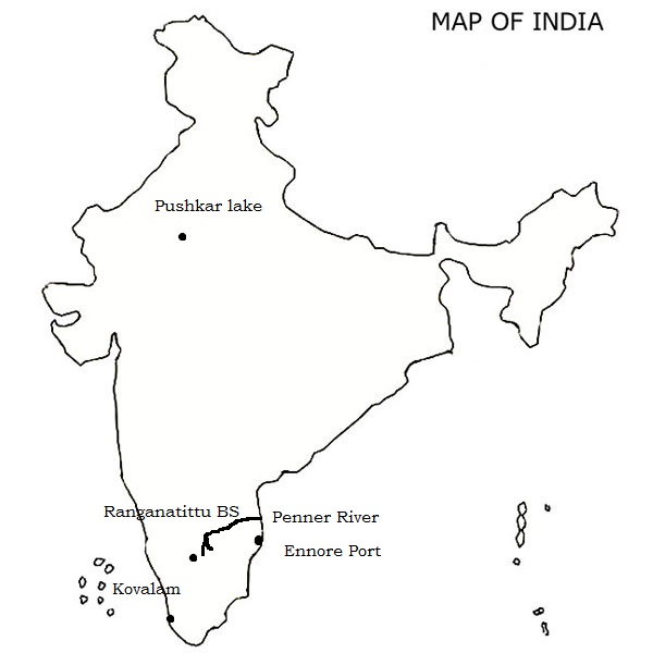
Q.1) On the outline map of India, mark the location of all the following. Write the significance of these locations, whether physical/commercial/economic/ecological/ environmental/cultural, in not more than 30 words for each entry.: (2 x 5 =10 marks)

i) Ranganthittu bird sanctuary
Ranganthittu Bird Sanctuary, also known as Pakshi Kashi of Karnataka, is a bird sanctuary in the Mandya District of the state of Karnataka in India. It is the largest bird sanctuary in the state and comprises six islets on the banks of the Kaveri river. Ranganthittu is located three kilometers away from the historic town of Srirangapatna and 16 kilometres (9.9 mi) north of Mysore.
ii) Pushkar lake
Pushkar Lake or Pushkar Sarovar is in the town of Pushkar in Ajmer district of the Rajasthan state of western India. Pushkar Lake is a sacred lake of the Hindus. The Hindu scriptures describe it as “Tirtha-Raj” – the king of pilgrimage sites related to a water-body and relate it to the mythology of the creator-god Brahma, whose most prominent temple stands in Pushkar. The Pushkar Lake finds mention on coins as early as the 4th century BC.
Pushkar Lake and its precincts become very heavily populated during the annual Pushkar Fair or Pushkar mela, which has both a religious as well as an economic aspect. During the fair, a very large gathering of pilgrims takes a holy dip in the lake and the camel fair is an adjunct celebration.
iii) Kovalam
Kovalam is a beach town by the Arabian Sea in Thiruvananthapuram metropolitan area in Kerala. Kovalam has three beaches separated by rocky outcroppings in its 17 km coastline, the three together form the famous crescent of the Kovalam beach.
- Lighthouse Beach- The southernmost beach.
- Hawah Beach- Eve’s Beach, more commonly known as Hawa Beach.
- Samudra Beach- A large promontory separates this part from the southern side.
iv) Ennore port
Ennore Port lies on the northeastern corner of the Chennai City of Tamil Nadu State on a flat coastal plain known as the Eastern Coastal Plains. It is located on the east coast of the Indian peninsula known as the Coromandel Coast in the Bay of Bengal and is situated 2.6 km north of the Ennore creek. Being coastal and situated on the thermal equator zone, the port experiences minimal variations in seasonal temperature ranging from a maximum of 38–42 °C in summer to a minimum of 18–20 °C in winter.
The weather is hot and humid for most of the year, and the region features a tropical wet and dry climate. The northeast monsoon winds bring seasonal rainfall in the region from September to December, and occasionally cyclones. The port is located on a region that falls under Seismic Zone III indicating a moderate risk of earthquake. The Ennore creek in the south separates the port from the town of Ennore.
v) Penner river
The Penna (also known as Pennar, Penner, Penneru or North Pinākinī) is a river of southern India. The Penna rises in Nandi Hills in Chikballapur District of Karnataka state, and runs north and east through the states of Karnataka and Andhra Pradesh to empty into the Bay of Bengal.
The river basin lies in the rain shadow region of Eastern Ghats and receives 500 mm average rainfall annually.
Q.2) Explain the following terminologies in about 50 words each: (5 x 5 =25 marks)
Answer
i) Thunderstorms
Thunderstorms are storms produced by a cumulonimbus cloud and always accompanied by lightening and thunder. They are usually of short duration, seldom 2 hours. They are accompanied by strong wind gusts, heavy rain and, sometimes hail.
Presence of warm and humid air in the lower layers of the atmosphere is necessary condition for the development of thunderstorms. Atmospheric instability and intense connective activity are other important requirements for their origin and growth.
A thunderstorm represents the weather phenomenon which combines strong wind gusts, thunder, lightning, torrential rains and cumulonimbus clouds etc. all in one. That is why thunderstorms are considered as a weather factory.
ii) Tornadoes
Tornado is defined as a violently rotating column of air attended by a funnel-shaped or tubular cloud extending downward from the base of a cumulonimbus cloud.
- Tornadoes are the most violent of all the storms.
- They are very small in size and of short duration.
- Tornadoes are also called ‘twisters! or cyclones.
- They are intense centres of low pressure having a whirlpool-like structure of winds rotating around a central cavity where a partial vacuum is produced by the centrifugal forces.
- The velocity of winds revolving tightly around the core reaches more than 300 km per hour.
- The diameter of this small-sized violent storm varies from 150 to 600 meters.
- The speed at which these storms travel over the ground is estimated to be 30 to 45 kilometers per hour.
- The length of the path of a tornado may be more than 26 kilometers.
iii) Anticyclone
An anti-cyclone — also known as a high-pressure area — is a large atmospheric circulation system with the wind flowing clockwise around it in the Northern Hemisphere, and counter-clockwise in the Southern Hemisphere.
Anticyclones form air masses cooling more than their surroundings, which causes the air to contract slightly making the air more dense. Since dense air weighs more, the weight of the atmosphere overlying a location increases, causing increased surface air pressure.
The air mass cooling that results in an anticyclone forming can be caused by either conduction as the air flows over a relatively cool ocean surface, or through the loss of infrared radiation over land during the fall, winter, or spring when little sunlight is available to warm the air mass.
iv) Frontolysis
The dying of a front is called Frontolysis. Frontolysis also does not happen all of a sudden. The process of Frontolysis must happen for quite some time to destroy the existing front.
Frontolysis, or the dissipation of a front, occurs when either the temperature difference between the two air masses disappears or the wind carries the air particles of the air mass away from each other. Frontolytical processes are more common in the atmosphere than are frontogenetical processes.
v) Waterspouts
Waterspout is a column of violently rotating air over water having a similarity to a dust devil of tornado. In other words, tornadoes and weak visible vortices occurring over water are called waterspouts. They are found over the tropical and subtropical oceans.
- Diameter of waterspouts ranges from a few meters to a few hundred meters.
- Wind speeds in these revolving storms may vary from 72 to 215 km per hour.
- It may be pointed out that waterspouts are never as intense as the tornadoes.
Q.3) Compare the origin and weather conditions associated with the tropical and temperate cyclones. (2016) (20 marks)
Approach
- The question is direct and straight forward. Introduce with the definition of cyclones.
- Compare the parameters associated with the origin of temperate and tropical cyclones.
- Compare the parameters associated with weather conditions of temperate and tropical cyclones.
- Conclude with significance of cyclones in latitudinal heat exchange.
Answer
A system of winds rotating inwards to an area of low barometric pressure, with an anticlockwise (northern hemisphere) or clockwise (southern hemisphere) circulation is called as cyclone.
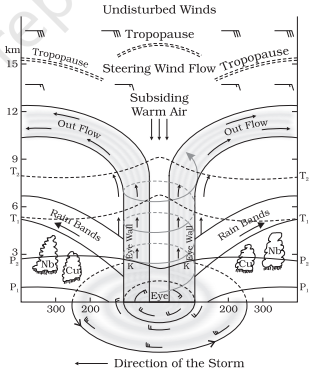
A tropical cyclone is a rapidly rotating storm system characterized by a low-pressure center, a closed low-level atmospheric circulation, strong winds, and a spiral arrangement of thunderstorms that produce heavy rain.
The following are some necessary conditions required for the formation of tropical cyclones.
- Large and continues supply of warm and moist air.
- Large value of Coriolis force.
- Existence of weak tropical disturbances.
- Upper-level outflow.
- Weak vertical winds hear in the basic current.
- Small atmospheric vortices in the ITCZ.
The temperate or frontal cyclones are large travelling atmospheric cyclonic storms up to 2,000 km in diameter. These are the dominant weather event of the Earth’s mid-latitudes, forming along the polar front. These are the result of dynamic interaction of warm tropical and cold polar air masses at the polar front.
The four stages in the life cycle of an extratropical cyclone are (i) the initial stage, (ii) the incipient stage (iii) the mature stage (iv) the occlusion stage.
Comparison of Origin
| Parameters | Tropical cyclone | Temperate cyclone |
| Source of origin | Over large water body surface i.e. seas and oceans. (surface temperature must be more than 270 Celsius) | Over mid-latitude land mass. Can also form on water bodies. |
| Latitudinal extent | 50 to 300 North and South | 300 to 600 North and South. More pronounced in Northern hemisphere due to greater temperature contrast. |
| Season | In late summers i.e., August to October. | Irregular. Few in summer and more in winter. |
| Airmass involved | Large and continuous supply of warm and moist air (mT) | Formation of polar front by tropical (cT) and polar (cP) |
| Driving force | The tropical cyclone derives its energy from the latent heat of condensation, and the difference in densities of the air masses does not contribute to the energy of the cyclone. | The energy of a temperate cyclone depends on the densities of air masses. |

Figure.3.1. Tropical cyclone

Figure 3.2 clouds associated with Temperate cyclone
Comparison of weather conditions
| Parameters | Tropical | Temperate |
| Rainfall | Heavy rainfall but does not last beyond a few hours. If the cyclone stays at a place, the rainfall may continue for many days. | In a temperate cyclone, rainfall is slow and continues for many days, sometimes even weeks. |
| Wind Velocity and destruction | Much greater (100 – 250 kmph) (200 – 1200 kmph in upper troposphere) Greater destruction due to winds, storm surges and torrential rains. | Comparatively low. Typical range: 30 – 150 kmph. Less destruction due to winds but more destruction due to flooding. |
| Isobars | Complete circles and the pressure gradient is steep | Isobars are usually ‘V’ shaped and the pressure gradient is low. |
| Temperature distribution | The temperature at the center is almost equally distributed. | All the sectors of the cyclone have different temperatures |
| Presence of calm region | The center of a tropical cyclone is known as the eye. The wind is calm at the center with no rainfall. | In a temperate cyclone, there is not a single place where winds and rains are inactive. |
| Clouds | The tropical cyclones exhibit fewer varieties of clouds – cumulonimbus, nimbostratus, etc. (refer figure 3.1) | The temperate cyclones show a variety of cloud development at various elevations. (refer figure 3.2) |
| Surface anti-cyclones | The tropical cyclones are not associated with surface anticyclones and they have a greater destructive capacity. | The temperate cyclones are associated with anticyclones which precede and succeed a cyclone. These cyclones are not very destructive. |
Both tropical and temperate cyclones are the result of the heating of the earth surface. And both are engines of latitudinal heat exchange. They transport the heat and keep helps in keeping the temperature atmosphere intact.
Q.4) Classify airmass and explain how ‘cP ‘airmass affects global climate (2012) (15 marks)
Approach
- The question is both direct and application oriented.
- Define airmass in introduction. Then briefly represent their classification on source regions, thermodynamic and dynamic changes.
- Then write in detail about effect of cP airmass on climates of America, Asia and Europe.
- Conclude with economic or social significance.
Answer
Airmass is an immense body of air, usually 1600km or more across, and several kilometers thick, which is characterised by homogenous physical properties viz. temperature and moisture content.
Classification of airmass
Based on source regions as well as nature of their surface following four principle types of airmasses are considered.
- Maritime tropical (mT);
- Continental tropical (cT);
- Maritime polar (mP);
- Continental polar (cP);
Besides this, when the thermodynamic and mechanical modification of airmass are taken into account, a more elaborate classification can be done as follows.

Figure 4.1 airmass classification
Effect of cP airmass on global climate
cP airmass has origin in continental regions of the polar latitude. These airmass are dry (very low moisture content) and cold (due to origin from polar regions).
cP airmass effects in N. America
- Originates over snow covered interior regions of Alaska and Canada. They are dry and cold, relatively stable in their source regions.
- This airmass moves from polar region towards south and eastern parts of N. America in between Rocky Mountains and great Lakes.
- As the land area is warmer, the cPW is heated from below and becomes unstable, causes lake-effect snow.
- These modified air masses are further forced to raise over Appalachians, resulting in overcast and heavy snowfall on western side of Mountains.
- In the east central of US, this cPW airmass comes in contact with the tropical mTK and a polar front comes into existence, results in winter precipitation. Ground is sometimes covered with dense fogs.
In Asia
- During winter originate over regions of central-eastern Siberia and outer Mongolia.
- When they move towards Pacific Ocean moving over China, the inversion of temperature brakes and results in convectional rains in the China.
- They enter India from the western end of Himalayan mountain barriers and produce winter precipitation in association with extra-tropical cyclones.
In Europe
- The source region for cP air mass are over northern Russia, Finland, and Lapland.
- The cP airmasses are observed over Europe in connection with an anticyclone centered over northern Russia and Finland.
- Because of the cP air, clouds are usually absent over the continent. Fair-weather cumulus are the typical clouds when cP air is observed over the British Isles.
- Over the Mediterranean, cP air soon become unstable and give rise to cumulus and cumulonimbus clouds with showers.
- Occasionally these air masses initiate the development of deep cyclonic systems over the central Mediterranean. Visibility is usually good; however, after this type becomes modified, haze layers form and reduce the visibility.
The cP airmass is one of the constituents of western disturbance in India which sustains the growth of Rabi crops.
Q.5) Explain the drought scenario across India in the south-west monsoon period of the year 2018. (20 marks)
Approach
- Define drought in the introduction.
- Explain the feature of droughts in S-W monsoon.
- Explain the trend for the year 2018.
- Write socio-economic effects.
- Conclusion by suggesting drought resilient efforts.
Answer
Drought is a prolonged period of shortage of water due to inadequate rainfall, excessive rate of evaporation and over utilization of water from reservoirs and other storages including ground water.
Monsoon rainfall is seasonal in nature 80% falls in four months (June-September) and rest of the 20% in remaining 8 months. Drought is typical to the nature of monsoonal rainfall. The spatial distribution of S-W monsoon rainfall is highly uneven owing to this some pockets of regions experience droughts.
The other feature of S-W monsoon is breaks in between the two rainfalls. Due to this there will be drought in some areas of the nation.

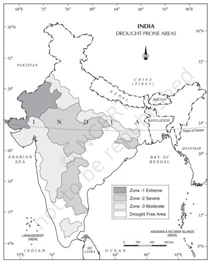
Figure 5.1. Drought prone areas of India
The figure above represents the drought regions of India based on severity. But in 2018 S-W monsoon the drought is more pronounced than usual.
As per the IMD 255 districts of the country recorded deficient (-59 to -20 per cent) or scanty (-99 to -60) rainfall. These districts account for 31 per cent of all districts in India where drought has been declared on the pretext of a deficit Southwest monsoon.
The post-monsoon analysis report of IMD shows that India received 91 per cent of monsoon from its Long Period Average. In Gujarat, Saurashtra and Kutch regions received -34% deficit rainfall, whereas East and South Gujarat recorded a deficit of -24 per cent. Assam has received -26 per cent of deficit rainfall.
A large chunk of Uttar Pradesh received 40 per cent deficit monsoon. West Bengal received deficit rainfall of more than 20 per cent.
More than 50 per cent of the districts in Bihar, Jharkhand, West Bengal, Gujarat, Tamil Nadu, Meghalaya, Karnataka, Arunachal Pradesh and Goa received deficient rainfall.
Socio-economic effects of drought
- Due to drought there will be loss of production in agriculture. This causes economic hardships to the rural economy. Which in turn projects to urban economy.
- Scarcity of water, food and fodder. Loss of lives both human and animals.
- Loss of employment in agriculture and increased migration to urbans.
- Increased inequality in income.
- Increased morbidity and epidemics. Etc
Government and the agrarian society should adopt towards drought resilient measures like.
- Agro-ecological support of subsistence-oriented farms
- Agricultural investments and finance in small-scale agriculture
- Promoting irrigated agriculture
- Social security systems, food security and long-term development
- Fragility and its interaction with sector approaches to combating hunger
- Results-based approaches and results-based management
