GAWP 2019 Day-7 Synopsis
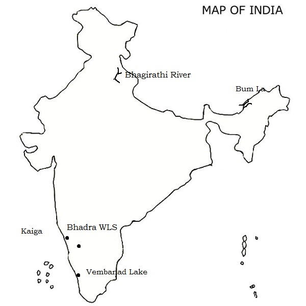
Q.1) On the outline map of India, mark the location of all the following. Write the significance of these locations, whether physical/commercial/economic/ecological/ environmental/cultural, in not more than 30 words for each entry.: (2 x 5 =10 marks)

i) Bhagirathi river
Bhāgīrathī is a turbulent Himalayan river in the Indian state of Uttarakhand, and one of the two headstreams (or source) of the Ganges, the major river of Northern India and considered holy in Hinduism. In Hindu faith and culture, the Bhagirathi is considered the source stream of the Ganges. However, in hydrology, the other headstream, Alaknanda, is considered the source stream on account of its great length and discharge.
The river flows from its source for 205 km (127 mi) before meeting the Alaknanda River at an elevation of 475 m (1,558 ft) in the town of Devprayag. Downstream of this confluence, considered holy by Hindus, the river is known as the Ganga Ji, or Ganges River by westerners. The controversial Tehri dam lies at the confluence of the Bhāgirathi and the Bhilangna.
ii) Bhadra wildlife Sanctuary
Bhadra Wildlife Sanctuary is a protected area and a tiger reserve as part of Project Tiger, located 23 km (14 mi) south of Bhadravathi town and 38 km (24 mi) northwest of Chikkamagaluru town in Karnataka state, India Bhadra sanctuary has a wide range of flora and fauna and is a popular place for day outings. The 1,875 m (6,152 ft) above MSL Hebbe Giri is the highest peak in the sanctuary.
The 551 ft (168 m) high Hebbe Falls are in the eastern part of the sanctuary. The Manikyadhara Falls is located on the nearby sacred Baba Budan Giri Hill, The tributaries of the Bhadra river flow west through the sanctuary.
iii) Bum la
The Bum La Pass is located about 37 km away from Tawang in Arunachal Pradesh, at the Indo-China border above 15,200 ft above sea level.
The road to Bum La is also a historical route, the People’s Liberation Army of China invaded India during the 1962 Sino-Indian War. Here in Bum La Pass one of the fiercest battle took place in the 1962 Sino-Indian War.
In 2006, Bumla pass was re-opened to traders for the first time in 44 years. Traders from both sides of the pass were permitted to enter each other’s territories, in addition to postal workers from each country
iv) Vembanad
Vembanad (Vembanad Kayal or Vembanad Kol) is the longest lake in India, and the largest lake in the state of Kerala. Spanning several districts in the state of Kerala, it is known as Vembanadu Lake in Kottayam, Punnamada Lake in Kuttanad and Kochi Lake in Kochi. Several groups of small islands including Vypin, Mulavukad, Vallarpadam, Willingdon Island are located in the Kochi Lake portion. Kochi Port is built around the Willingdon Island and the Vallarpadam island.
The Nehru Trophy Boat Race is conducted in a portion of the lake. Vembanad Lake is at the heart of Kerala Backwaters tourism with hundreds of kettuvallams plied on it and numerous resorts on its banks. The Kumarakom Bird Sanctuary is located on the east coast of the lake. The lake has become a major tourist attraction.
v) Kaiga
Kaiga Generating Station is a nuclear power generating station situated at Kaiga, near the river Kali, in Uttar Kannada district of Karnataka, India. The plant has been in operation since March 2000 and is operated by the Nuclear Power Corporation of India.
Q.2) Explain the following terminologies in about 50 words each: (5 x 5 =25 marks)
i) Insolation
Insolation is the solar radiation that reaches the earth’s surface. It is measured by the amount of solar energy received per square centimeter per minute. Insolation affects temperature. The more the insolation, the higher the temperature. In any given day, the strongest insolation is received at noon.
- Factors affect insolation (without the effect of the atmosphere)
- Angle of the sun
- Distance between the sun and the earth
- Duration of daylight
- The longer the duration of daylight, the more the insolation received per day.
ii) Heat budget
The earth as a whole does not accumulate or loses heat. It maintains its average temperature. This can happen only if the amount of heat received in the form of insolation equals the amount lost by the earth through terrestrial radiation. This balance between the insolation and the terrestrial radiation is termed as the heat budget or heat balance of the earth.
This is why the earth neither warms up nor cools down despite the huge transfer of heat that takes place.
iii) Temperature anomaly
The difference between the mean temperature of a place and the mean temperature of its parallel (latitude) is called the temperature anomaly or thermal anomaly. It expresses deviation from the normal. The temperature variation along a latitude varies on account of altitude, land-water contrasts, prevailing winds and ocean currents.
The largest anomalies occur in the northern hemisphere and the smallest in the southern hemisphere. The anomaly is said to be negative when the temperature at a place is less than the expected temperature of the latitude. Conversely, the anomaly is positive when the temperature at a place is more than the expected temperature of the latitude.
iv) Inversion of temperature
Temperature inversion is condition in which the temperature of the atmosphere increases with altitude in contrast to the normal decrease with altitude. When temperature inversion occurs, cold air underlies warmer air at higher altitudes.
Normally, temperature decreases with increase in elevation. It is called normal lapse rate. At times, the situations is reversed and the normal lapse rate is inverted. It is called Inversion of temperature. Inversion is usually of short duration but quite common nonetheless.
Types of inversion are
- Ground surface inversion
- Upper air inversion
- Advocational inversion
- Frontal or cyclonic inversion
- Valley inversion
v) Advection
Advection is a lateral or horizontal transfer of mass, heat, or other property. Accordingly, winds that blow across Earth’s surface represent advectional movements of air. Advection also takes place in the ocean in the form of currents. Currently, geologists debate the presence and role of substantial advective processes in Earth’s mantle.
Advective winds move from areas of higher temperature toward areas of lower temperature. In contrast, convection, the vertical movement of mass or transfer of heat, manifests itself as air currents. Accordingly, winds are a result of advection, while air currents are a result of convection.
Q.3) What are isotherms? Enumerate its features. Explain the Horizontal distribution of temperature for the month of July. (20 marks)
Approach
- The question is very straight forward and easy to answer. So, define isotherms in the introduction.
- List the features of isotherms
- Then explain the horizontal distribution of temperature for the month of July along with diagram.
- Conclude with the significance of isotherms.
Answer
An isotherm is a line joining places having equal temperatures. In drawing isotherms, the temperature are reduced to sea level to eliminate the effect of sea altitude.
Three general characteristics of isotherms are to be noted:
- Isotherms trend east- west, generally following the parallels,
- because of land-water contrasts, isotherms take sudden bends at land-water edges, and
- the spacing of isotherms Indicates the latitudinal thermal gradient.
- Close placing of isotherms indicates a rapid change in the temperature over latitudinal parallels, and the wide, spacing is a measure of slow change.
July month isotherm distribution:
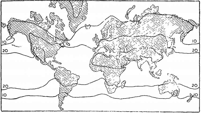
At this time, the maximum temperature of above 30 deg. C occurs entirely in the Northern Hemisphere between 10 deg. and 40 deg. N latitudes. The areas Included are the south-western U.S.A., the Sahara, Arabia, Iraq, Iran, Afghanistan, the Gobi Desert, large parts Of China, and the area surrounding Madras in India. The minimum temperature occurs in the Northern Hemisphere, and in the central parts of Greenland the temperature below zero (Fig. 3).

Isotherms bend equatorward while crossing the oceans, and poleward while crossing the land masses. Isotherms reveal the wider spacing on the oceans than on the continents. Hence, the temperature gradients are gentler in summer than in winter. Also, isotherms are more regular in the Southern than the Northern Hemisphere.
Isotherms helps us to analyze the temperature distribution on the land and ocean in the laboratories. This is very useful for marine transportation via ships and vessels.
Q.4) Explain the meridional circulation of the atmosphere and its importance in world climate. (2015) (15 marks)
Approach
- Briefly introduce the atmospheric circulation.
- Explain the meridional circulation.
- Its importance in world climate.
- Conclude with its shortcomings.
Answer
Atmospheric circulation is the large-scale movement of air by which heat is distributed on the surface of the Earth.
The wind belts and the jet streams girdling the planet are steered by three convection cells: the Hadley cell, the Ferrell cell, and the Polar cell.
Meridional circulation
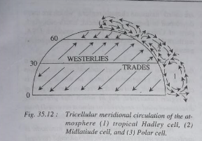
The three-cell model of meridional circulation of the atmosphere popularly known as tricellular meridional circulation of the atmosphere is the most accepted model, wherein it is believed that there is cellular circulation of air at each meridian (longitude).
Surface winds blow from high pressure areas to low pressure areas but in the upper atmosphere the general direction of air circulation is opposite to the direction of surface winds. Thus, each meridian has three cells of air circulation in the northern hemisphere e.g.
(i) tropical cell or Hadley cell,
(ii) polar front cell or midlatitude cell or Ferrell cell, and
(iii) polar cell.

Figure.4 meridional circulation (1) Headley cell, (2) polar front cell, (3) polar cell
(i) Tropical cell is also called as Hadley cell because G. Hadley first identified this thermally induced cell in both the hemispheres in the year 1735. The winds gets heated due to very high temperature at the equator ascend upward. These ascending warm and moist winds release latent heat after condensation which causes further ascent of the winds which after reaching the height of up-to 12 kilometers in the troposphere over the equator diverge northward and southward or say poleward.
The surface winds in the name of trade winds blow from subtropical high-pressure belts to equatorial low-pressure belt in order to replace the ascending air at the equator. The upper air moving in opposite direction to surface winds (trade winds) is called antitrade.
These so-called upper air antitrades descend near 30 deg.-35deg. latitudes to cause subtropical high-pressure belt. This is the site of world’s tropical deserts. These antitrades after descending near 30deg.-35deg. latitudes again blow towards the equator where they are again heated and ascend.
Thus, one complete meridional cell of air circulation is formed. This is called tropical meridional cell which is located between the equator and 30deg. latitudes.
It is important to mention that the so-called antitrades are not affected by friction and while moving from low to high latitudes these upper tropospheric winds are subjected to Coriolis force as a result of which they are deflected and become geostrophic westerlies.
In the upper circulation of tropical cell, it has been found that the jet streams are prevalent throught the year. In the northern hemisphere in summer the sub-tropical westerly jet stream is replaced by easterly jet stream.
(2) Polar front cell or mid-latitude cell
Surface winds, known as westerlies, blow from the subtropical high-pressure belt to subpolar low-pressure belt (60deg.-65deg.). The winds ascend near 60-65 deg. latitudes because of the rotation of the earth and after reaching the upper troposphere diverge in opposite directions (pole ward and equatorward).
These Winds (which diverge equatorward) again descend near horse latitudes (300-350 latitudes) to reinforce subtropical high-pressure belt. After descending these winds again blow poleward as surface westerlies and thus a complete cell is formed. This is called as Ferrell cell.
But as observed by Rossby the westerly flow exists also for the upper troposphere, contrary to the old concept of easterly. This is due to the poleward decrease of temperature.
And as observed by Trewartha the westerly flow of the wind seen, ascending the polar front and breaking through near tropopause. Major heat exchange takes place at the surface and aloft. And hence its is also called as polar front cell.
It may be pointed out that this new concept does not explain the cellular meridional circulation in the middle latitudes.
(3) Polar cell involves the atmospheric circulation prevailing between 60deg. and poles. Cold winds, known as polar easterlies, blow from polar high-pressure areas to sub-polar or mid- latitude low pressure belt. The general direction of surface polar winds becomes easterly (east to west) due to Coriolis force.
These polar cold winds converge with warm westerlies near 600 -650 latitudes and form polar front or mid-latitude front which becomes the centre for the origin of temperate cyclones. The winds ascend upward due to the rotation of the earth at the subpolar low pressure belt and after reaching middle troposphere they turn poleward and equatorward.
The poleward upper air descends at the poles and reinforce the polar high pressure. Thus, a complete polar cell is formed.
Further the ideas of Palmen and Newton along with that of Rossby and Trewartha has been made to adopt a new model where in the Ferrell cell is completely omitted.
Importance of Meridional circulation on world climate.
- Meridional circulation of the surface wind system is very significant in the latitudinal heat balance of the earth.
- The belt of doldrums or the inter-tropical convergence Zone (ITCZ) is the most important and uninterrupted belt of convergence on the surface of earth.
- The modern version of the theory explains the formation of wave cyclones or temperate cyclones.
- The low pressure and high-pressure distribution and the shifting of pressure belts over the Earth’s surface virtually control air movement around the world.
- The development of tropical cyclones, temperate cyclones, and anticyclones is also the result of meridional circulation.
- The areas of divergence and convergence are known as centers of action, for it is along boundaries that most of the cyclones and anticyclones move out from one region to another.
Though the concepts explain the general atmospheric circulation, it had also faced objection for considering the temperature as the sole criteria for the atmospheric circulation.
Q.5) MSME segment is called as Engines of Growth. Elucidate. Why there is a need for technology infusion in MSMEs explain? (15 marks)
Reference – Kurukshetra October 2018 magazine.
Approach
- Introduce by defining MSME sector.
- Write points with facts, data, and examples which supports the statements MSME are Engines of Growth.
- Need of technology infusion in MSME (3-4 points)
- Conclusion with suggestion.
Answer
The Micro, Small and Medium Enterprises (MSME) are classified in two Classes: The Manufacturing Enterprise are defined in terms of investment in Plant & Machinery. And the enterprises engaged in providing or rendering of services and are defined in terms of investment in equipment.
MSME are Engine of Growth because of following reasons
- MSME contributes about 45% of manufacturing output, exports about 40% of the total exports and employment about 69 million persons in over 29 million units throughout the country based on the Planning Commission, 2012.
- MSMEs have lower capital-output and capital-labour ratios than large-scale industries, and therefore, better serve growth and employment objectives.
- MSMEs seen average annual growth rate of 4.4% in the number of units and 4.62% in employment.
- MSMEs units act as ancillary industries for Large Scale Industries providing them with raw materials, vital components and backward linkages.
- MSMEs are instruments of inclusive growth. It is the only source of livelihood (except agriculture) for most of the vulnerable sections.
Need of technology infusion in MSME sector
- Technology is the enabler of growth.
- Creating innovation and technology ecosystem is pertinent for commercializing inventions for value added products and services.
- The adoption of new technologies is essential for growth and it is indisputable.
- Efficient usage of resources/manpower.
- Improved Quality assurance/certification.
Non-Availability of technology, infrastructure and managerial competence, and limitations posed by labor laws, taxation policy, market uncertainty and imperfect competition are impediment to the growth of MSMEs. Government should act to remove these hurdles.
